OFFA'S DYKE PATH MAY 2019.
Left Click on photo's to enlarge, then left click off the photo to return to the blogg.
Two backpacking trips I have had on my mind for several years are the Cape Wrath Trail and the Cambrian Way, with the latter being of extra interest. However due to ongoing hip/thigh problems, which I have accepted are due to physiological degeneration rather than straight forward injuries, I have become doubtfull that I could now manage either of them, and certainly not at at a fast schedule that I prefer.
Putting off regular walking like I used to do over the last few years as a result of issues, and realising that they were not going to resolve anytime soon, I wanted a hard test to see if it was at all still possible.
I had walked Offa's Dyke some 20+ years ago with a pal over 11 days, carrying a lightish pack using b&b accomodation all the way. We had a rest day in Knighton.
Fit at the time as I was still road, fell, and cross country running as well as frequent hill walking and doing my own solo ultra distance walks. 20+ years younger and a full stone lighter.
I remember it as being a comfortable but hard, very undulating route with numerous steep ascents.
I also attempted the King Offa's Dyke Ultra race in September 2017 after being a volunteer manning the CP at Pen Y Strytt, the year before. I retired from the race after reaching Kington due to strained hip/thigh muscle tendons. I have continued to have problems in this area ever since, probably due to being unable to rest properly in my work as a self employed professional cleaner.
I decided that this would be a good test, come what may, and set myself a target of sub 5 days for the full route. I would be carrying more weight than the two earlier trips, as I would be backpacking carrying tent and all. If I had known just how tough the route would be to backpack it, all walking, within that time and the accompanying hot weather, I would have chosen another route or aimed for a 6 day limit at least.
At 73 years I also realised that if successful, I would most likely set an over 70's FKT (Fastest Known Time) and possibly O/60's etc backpacking at least.
Andy Cole set the actual FKT for an O/60 year old, with his superb finish of the King Offa's Dyke Ultra Race 2017.
A couple of days beforehand I visited an Osteopath as I needed to know if the problems were down to the joint or soft tissue. His opinion was that it was more soft tissue. Rightly or wrongly his opinion, it was enough for me and two days later I'm in Chester with Pat.
We stayed over for two nights exploring the area. On the Saturday morning, I was up at 3am and driving to Prestatyn, where I parked my car (Pat was getting the train back home from Chester) and headed to the rail station for the 5.27am train to Chepstow, to begin my attempt on the Offa's Dyke Path.
Basically the plan was as usual, walk as many of the daylight hours as possible, keep a good pace, purchase supplies as and when, try to have a decent meal daily in cafe or pub, be prepared to use b&b, offload gear, or bale out as a last resort.
I was hoping to get some sleep during the 4 hour train journey but that didn't happen. I had pre cut my foot protection, (paper tape) and applied it, adding a Compeed plaster to the balls of both feet.
(At the end of each day and before getting my head down, I would take an Ibuprofen, then before setting off again I would apply Voltarol Gel to my thigh and Hip area.)
After arriving in Chepstow, I stocked up on supplies and walked the 1.5 miles to Sedbury Cliffs to start.
DAY 1. SEDBURY - HENDRE (24 miles)
(Ascent - 3,900ft.)
It was beginning to warm up but with quite a cool breeze.
I was focussed on reaching Monmouth as soon as possible and set off at a good pushing pace.
Soon the first of the steep ascents was met.
Hip and thigh twitching, by the 4th undulation both my right knee and hip were trying to give way every time I put pressure on them. However by mile 10 they began to settle down, which surprised me sime.
I met a couple doing b&b and taking 15 days over the route. After a brief chat I moved ahead. Reaching the road I looked for the left turn off it, and headed down the quiet lane. A mile later I realised I'd left the road too soon so did an about turn. Back on the road I could see the couple again, and they were surprised when I approached from behind. "That's what happens when you don't put your glasses on", I said, as I passed once more.
Pressing on, up and down, many times, it came back to me just how tough this route was.
I was however determined to get beyond Monmouth before stopping for the night.
I began passing walkers doing the route, which was remarkedly well signed, the paths more worn and the horrible high stiles replaced with new looking metal gates.
After 19+ miles I arrived in Monmouth after 6.5 hours, only an hour slower than when I did the Ultra Race, but this time with no running and a 10kg+ sack on my back.
I entered the last pub before the bridge and ordered a Beef Chilli and pint of Guinness.
After I left I carried on for another 3 miles before having a rest after yet another steep climb out of the forest. A young lady runner came up the track and stopped for a chat. She told that there was a good camp site a mile further on with all facilities. I carried on and was soon pitching my tent.
I thought about having a shower but opted for a good upper body wash in the shower instead.
Hoping for a good sleep, but failled badly, my legs couldn't settle after an exhausting multi ascending day.
DAY 2. HENDRE - HAY ON WYE (27 miles)
(Ascent - 4,400ft)
It was no use so I unpitched and set off again at 2am.
It was a cold morning so I donned trackster bottoms, thermal top, windproof to and full water proofs.
My target today was at least Hay on Wye, I was hoping for more as I needed to average 35 miles a day to get in under 5 days, and Hay on Wye was only 30 miles.
I knew it was reasonably easy going as far as Pandy after which was the ascent onto the Hattersall Ridge with which I had struggled during the Ultra.
Pandy was reached and straight through. Just as I was finishing a sandwiche before starting the ascent, two fast paced runner/walkers came through the gate and said "Hello". I replied the same, then it was a double take as I realised it was two of the Ultra volunteers. I had met them on a couple of occasions but could just not remember their names. They quickly dissapeared into the distance.
Actually the climb up onto the ridge itself was not as bad as I was expecting, perhaps my legs were becoming accustomed to all these ups and downs?
The ridge is 10 miles long, on the edge of the Black Mountains, part of the Brecon Beacons, and the path is more of a track. it ends with Hay Bluff, a steep descent which takes you to easier lower ground. However,I knew there was a slanting descent path before you reached the last top of Hay Bluff.
On reaching one of the tops, i came across a guy resting with his boots off. We had a good chat, he was an ex Para, doing the route North to south, as many others I had met, were doing. Supposedly easier according to their decision to go that way. He was on a 7 day attempt, but wishing he had chosen 10 days. He said he was, eyes down, just banging out the miles, saying there wasn't much to see, anyway!!?? I wondered if he was walking along with his eyes shut, the scenery is fantastic and the weather had been clear and good with good visibilty. I left him to it and carried on.
Perhaps I was looking forward to the descent more than I realised, because after what seemed like along time on the ridge I found what I thought the spot where the descent began. Down and down I went and finally reached the country lane at the bottom. Looking round nothing looked right, consulting my map and finally getting a gps fix I realised I had descended 3 miles too soon. I looked up towards the top of the ridge and the hard terrain between. In the far distance I could make out a track that would take me gradually up to roughly where the the ridge finished. However I immediately dismissed that idea, as I would deem that cheating. I had made a bad nav error so the only right thing to do was to get back on route as soon as possible. The only option was to re-ascend the steep pathless grass/heather slope. It took me an hour and much effort before I regained the ridge, but once there I could see the funny side and all those now ahead of me that I had overtaken a good while earlier.
Eventually I found the correct path off which was far more obvious than the earlier one I had taken.
Approaching Hay on Wye I caught up with yet more Australian walkers and walked the last mile or so with them. I sat on a bench there pondering what to do. Both days and particularly today my progress had been badly hampered at times with sleep deprivation (sleep monsters/demons) as we call them. Falling asleep on my feet and the pace dramatically slowing. I needed a good few hours sleep.
So that was it, I managed to book into a b&b, went to a local pub and had a meal then to bed early.
A wonderful sleep followed and I was away again in the morning at 3.45am.
DAY 3. HAY ON WYE - KINGTON - KNIGHTON - PAST HERGEN. (40 miles)
(Ascent 8,300ft)
Leaving the path alongside the River Wye the dew laiden long grass soaked the bottom part of my over trousers but only dampened the top of my socks. I set off each day in full waterproofs until I had warmed up and changed into shorts as soon as I could.
Legs tight and sore, took a couple of hours before feeling better. The steep ascents had me gasping, stopping often, hands on knees bent over catching my breath, then a few more steps up and same again. this was the theme for all the steep sections on this tortuous route, and I knew that the hardest section beyond Knighton was yet to come!
14 miles later including 4 miles of the Hergest Ridge, I arrived early in Kington.
A walker on his way out of the village passed as I headed for the cafe there and some breakfast. The place looked a little run down and in need of a good spruce up, I thought, however the breakfast was well appreciatted.
13+ miles now to Knighton, I thought about the terrain that was awaiting me thereafter.
After afew miles I caught up with the walker that I had seen earlier. He was taking it slowly as he didn't want to arrive in Knighton too early, as he had done in Kington the day before.
Knighton was my base target for today, although again, I really needed to get beyond there. It would also, despite the extra effort, be a psychological boost to get a good deal of that hard section done, rather than have it 'all' to do tomorrow.
Before Knighton however was the four considerable hills in between.

It began raining quite heavily as I reached Knighton. The only pub that was open wasn't doing meals until later, however I found a good cafe and got stuck into a vegatable soup followed by Chicken Korma and chips.
Still raining as I passed the Offa's Dyke Centre and began the long steep climb out of town and onto higher ground.
The arduous undulating terrain over the next 11 miles were strength sapping and had me cursing every long, ever steepening ascent, the rewards of which were the breathtaking scenery all around.

After 9pm I started looking for some flat ground to camp. Eventually at 9.30pm I found a suitable spot in a hollow by the side of the Dyke a little beyond Hergen.
Settling down in my tent I thought I heard animals snagging my guy lines and shouted to shy them away, then realised that the wind had got up and being funelled down the hollow causing the tent fabric to flap.
Awake up and away at 4.30am, I was looking forward to easier ground, bypassing Montgomery and the flat section alongside the River Severn, just one more long but testing climb after churchtown, then a long drop off to more even ground of Brompton.


 Easy going bypasing Mongomery, then undulations and rising terrain before a long descent, with Welshpool to the left below, I arrived at Buttington.


Alas another pub shut until later, I pressed on along the 10 mile flat section of the River Severn Valley towards Llanymynech.
The Sunrise led to an even hotter day, with me swivelling my cap to provide shade to my neck.
My sack by this time had gained weight to around 12kg or so with being forced to carry two days food and water just incase. This was due to the lack of supply and food opportunities after discovering early on, that pubs weren't open until 6pm and many villages passed through were devoid of a single shop.
Overheating but staying hydrated along the suntrap that was the valley, switching from one side of the A483 to the other, then alongside the river before leaving it to arrive at Four Crosses and another closed pub. Shortly after a left turn takes you on a lesser direct loop to Llanymynech following a lovely section along the disused, restored, Mointgomery Canal, a branch of the Shropshire Union Canal.

A mile or two off there I began to feel a bit strange and all strength disappeared. I was well hydrated but had been far too hot for too long. I knew that I wouldn't be able go beyond Llanymynech so reluctantly booked a b&b in the 4 Crosses Hotel, which sounds grand but is just a basic pub, adequate but basic.
Just after the lady left after showing me my room I suddenly had a bad attack of the Chills and shivered violently for several minutes. I realised that I had heat exhaustion and was thankful that I made the right decision.
After two cups of tea, a warm shower and change, I felt better. I got plenty supplies in the only open shop afterwhich I had a meal in the Green Dragon Pub.
Back to room, a good sleep but waking often, my alarm went off at 3am. Feeling sluggish, it took two hours, contemplating things and slowly getting ready, however once out the door and walking I felt better.
LLANYMYNECH - TREVOR - LLANDEGLA - BODFARI - PRESTATYN. (60 miles)
(Ascent - 10,900ft.)
Checking timings and with 60 mile remaining I knew that the only chance I had of success for a sub 5 day trip was to thru hike non stop all the way to Prestatyn.
I took it steady up the rising lane and short but stiff climb onto level ground overlooking the village. Relief at the following easy walking from there and long forest walk.
All I had to do was keep a steady pace, keep short stops to a minimum, and it was in the bag.
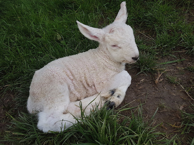
Nearing the top of the rise out of Llanymynech, I came across a little Lamb, which unusually didn't bolt out the way as I approached. It's mother was nearby keeping a watch. I was able to get right up to it, as it was right on the path. It didn't move, just occasionally opening its eyes, trembling, not looking good at all. Nothing I could do unfortunately, but didn't rate its chances unless its Shepherd came by soon.
Passing the b&b I had used in 2017, I was soon alongside the Shropshire Union Canal. A godsend narrowboat shop moored up had me purchasing a tub of ice cream and a packet of Wine Gums. I sat on the chair provided chatting with the lady owner on this yet another hot day.
Across the famous Pont-Cysyllte Aquaduct and over the bridge I stopped again for a coffee at another shop on the queyside, just before Trevor.

Many people were out enjoying the good weather and much Narrow Boat movement waiting their turn to cross the Aquaduct.
Heading now for Llandegla I relaxed some, now that most of the hard ascents were behind me and was looking forward to the high level road leading to 'worlds end' where I broke off and took the mountain path through the scree that falls down from the magnificent Limestone escarpment that dominates that hillside that looks down on Llangollen.

Through the forest, I headed for the pub in Llandegla, looking forward to a good meal. However they were not cooking that night so I had to make do with a couple of bags of crisps and pork scratchings.
The Clwydian Hills were next. The climbs now were more gradual and keep mostly to high ground over the five mountains.
High up a late local walker coming the other way, wondered what I was doing up there so late. he amused me when he asked if I was rough sleeper. I told him that I had no intention of sleeping, rough or otherwise, but was heading straight through to Prestatyn.
Not long afterwards, daylight faded and it was dark.
As I approached Bodfari after dropping down off the ridge, I twisted to close a metal gate that I'd just come through. I must have slightly shifted my weight backwards. My feet shot forward from beneath me on some loose gravel causing me to land heavily on my left elbow and right buttock, saved mostly by my backpack. As I got back to my feet I felt warm blood running down my arm, beneath my thermal top and Spine Goretex Jacket, which was holed in the event.
Straight through Bodfari and onto the final 12 miles. The ascents not quite over as the last section of Clwydian Hills called once more.

I was confident now that 5 days were all but done and indeed it proved to be after the clifftop route above Prestatyn. The begining of this route had me slightly confused as it was different to when I first did it and at times wondered if I was on the right path, however I just followed the Acorns.
Through Prestatyn towards the sea, I arrived at the Offa's Dyke Path finish exactly 4 days 22 hours and 55 minutes after setting off from Sedbury Cliffs.

In the cafe there I reflected on the walk, I loved the scenery, was fortuanate to have great weather, chatting to other wayfarers and in particular the route since Llanymynech.
Although the ascents were steeper and longer from Knighton to Brompton especially, they came in the mid section of the route when the legs were more accustomed to all the rises and falls. The harder section was without doubt from Sedbury Cliffs to Monmouth, which confirmed my thinking during the Ultra race. Although less than half the height gain, it was the first section and I am convinced that official guidebook ascent details don't tell a true story. Contours being every 10 metre, there are many, little but very steep ascents and descents of less than that, (so not included) but being so numerous they do take their toll on the legs.
I was satisfied that I had managed it inside of 5 days, however I had underestimated how tough it would be on that schedule whilst carrying a medium weight camping pack.
The heat didn't help or the lack of daytime facilities.
A 4.5 day Coast to Coast would be a breeze after this!
Kit:-
Osprey 58 litre rucksack
Tent, Terra Nova Photon Elite
Sleeping bag, Vango 400
Sleep mat, Alpkit
Maps and compass
Wallet etc
Headtorch, Petzl XRP
1st aid kit
Small wash kit
2 x Water bottles
Waterproof sack liner
GPS, Satmap 10+
Spot tracker
Mobile phone, Samsung S7
Spare batteries
Phone cable and charger
Map reading glasses
Midge headnet
Sun cream
Food and Water.
Gloves, cap, 2 x buffs, waterproof hat, windproof top, Spine Jacket, Alpkit w/p trousers, GTX gaiters, 2 x spare thermals, spare pr socks, shorts, sp boxers.
Food and Water.
Worn, socks, Meindl GTX shoes, tracksters, thermal top, hat, and all other spare spare clothes at different times, along the way.
I felt I got away with the minimum of gear, at times I wished that I had taken at least another thermal top and pair of shorts, due to the hot conditions. The only item I didn't use was the Midge Headnet.
Left Click on photo's to enlarge, then left click off the photo to return to the blogg.
Two backpacking trips I have had on my mind for several years are the Cape Wrath Trail and the Cambrian Way, with the latter being of extra interest. However due to ongoing hip/thigh problems, which I have accepted are due to physiological degeneration rather than straight forward injuries, I have become doubtfull that I could now manage either of them, and certainly not at at a fast schedule that I prefer.
Putting off regular walking like I used to do over the last few years as a result of issues, and realising that they were not going to resolve anytime soon, I wanted a hard test to see if it was at all still possible.
I had walked Offa's Dyke some 20+ years ago with a pal over 11 days, carrying a lightish pack using b&b accomodation all the way. We had a rest day in Knighton.
Fit at the time as I was still road, fell, and cross country running as well as frequent hill walking and doing my own solo ultra distance walks. 20+ years younger and a full stone lighter.
I remember it as being a comfortable but hard, very undulating route with numerous steep ascents.
I also attempted the King Offa's Dyke Ultra race in September 2017 after being a volunteer manning the CP at Pen Y Strytt, the year before. I retired from the race after reaching Kington due to strained hip/thigh muscle tendons. I have continued to have problems in this area ever since, probably due to being unable to rest properly in my work as a self employed professional cleaner.
I decided that this would be a good test, come what may, and set myself a target of sub 5 days for the full route. I would be carrying more weight than the two earlier trips, as I would be backpacking carrying tent and all. If I had known just how tough the route would be to backpack it, all walking, within that time and the accompanying hot weather, I would have chosen another route or aimed for a 6 day limit at least.
At 73 years I also realised that if successful, I would most likely set an over 70's FKT (Fastest Known Time) and possibly O/60's etc backpacking at least.
Andy Cole set the actual FKT for an O/60 year old, with his superb finish of the King Offa's Dyke Ultra Race 2017.
A couple of days beforehand I visited an Osteopath as I needed to know if the problems were down to the joint or soft tissue. His opinion was that it was more soft tissue. Rightly or wrongly his opinion, it was enough for me and two days later I'm in Chester with Pat.
We stayed over for two nights exploring the area. On the Saturday morning, I was up at 3am and driving to Prestatyn, where I parked my car (Pat was getting the train back home from Chester) and headed to the rail station for the 5.27am train to Chepstow, to begin my attempt on the Offa's Dyke Path.
Basically the plan was as usual, walk as many of the daylight hours as possible, keep a good pace, purchase supplies as and when, try to have a decent meal daily in cafe or pub, be prepared to use b&b, offload gear, or bale out as a last resort.
I was hoping to get some sleep during the 4 hour train journey but that didn't happen. I had pre cut my foot protection, (paper tape) and applied it, adding a Compeed plaster to the balls of both feet.
(At the end of each day and before getting my head down, I would take an Ibuprofen, then before setting off again I would apply Voltarol Gel to my thigh and Hip area.)
After arriving in Chepstow, I stocked up on supplies and walked the 1.5 miles to Sedbury Cliffs to start.
 |
| Sedbury Cliffs start. |
 |
| Tintern Abbey from the path. |
DAY 1. SEDBURY - HENDRE (24 miles)
(Ascent - 3,900ft.)
It was beginning to warm up but with quite a cool breeze.
I was focussed on reaching Monmouth as soon as possible and set off at a good pushing pace.
Soon the first of the steep ascents was met.
Hip and thigh twitching, by the 4th undulation both my right knee and hip were trying to give way every time I put pressure on them. However by mile 10 they began to settle down, which surprised me sime.
I met a couple doing b&b and taking 15 days over the route. After a brief chat I moved ahead. Reaching the road I looked for the left turn off it, and headed down the quiet lane. A mile later I realised I'd left the road too soon so did an about turn. Back on the road I could see the couple again, and they were surprised when I approached from behind. "That's what happens when you don't put your glasses on", I said, as I passed once more.
 |
| Redbrook Village below. |
 |
| The Kymin |
Pressing on, up and down, many times, it came back to me just how tough this route was.
I was however determined to get beyond Monmouth before stopping for the night.
I began passing walkers doing the route, which was remarkedly well signed, the paths more worn and the horrible high stiles replaced with new looking metal gates.
After 19+ miles I arrived in Monmouth after 6.5 hours, only an hour slower than when I did the Ultra Race, but this time with no running and a 10kg+ sack on my back.
 |
| River Wye, Monmouth |
 |
| Monmouth High Street. |
I entered the last pub before the bridge and ordered a Beef Chilli and pint of Guinness.
After I left I carried on for another 3 miles before having a rest after yet another steep climb out of the forest. A young lady runner came up the track and stopped for a chat. She told that there was a good camp site a mile further on with all facilities. I carried on and was soon pitching my tent.
 |
| 1st. Pitch, Farm Campsite at Hendre. |
Hoping for a good sleep, but failled badly, my legs couldn't settle after an exhausting multi ascending day.
DAY 2. HENDRE - HAY ON WYE (27 miles)
(Ascent - 4,400ft)
It was no use so I unpitched and set off again at 2am.
It was a cold morning so I donned trackster bottoms, thermal top, windproof to and full water proofs.
My target today was at least Hay on Wye, I was hoping for more as I needed to average 35 miles a day to get in under 5 days, and Hay on Wye was only 30 miles.
 |
| White Castle. |
 |
| Approaching Pandy. |
 |
| Brecon Beacons. |
Pandy was reached and straight through. Just as I was finishing a sandwiche before starting the ascent, two fast paced runner/walkers came through the gate and said "Hello". I replied the same, then it was a double take as I realised it was two of the Ultra volunteers. I had met them on a couple of occasions but could just not remember their names. They quickly dissapeared into the distance.
Actually the climb up onto the ridge itself was not as bad as I was expecting, perhaps my legs were becoming accustomed to all these ups and downs?
 |
| Hattersall Ridge Path. |
The ridge is 10 miles long, on the edge of the Black Mountains, part of the Brecon Beacons, and the path is more of a track. it ends with Hay Bluff, a steep descent which takes you to easier lower ground. However,I knew there was a slanting descent path before you reached the last top of Hay Bluff.
On reaching one of the tops, i came across a guy resting with his boots off. We had a good chat, he was an ex Para, doing the route North to south, as many others I had met, were doing. Supposedly easier according to their decision to go that way. He was on a 7 day attempt, but wishing he had chosen 10 days. He said he was, eyes down, just banging out the miles, saying there wasn't much to see, anyway!!?? I wondered if he was walking along with his eyes shut, the scenery is fantastic and the weather had been clear and good with good visibilty. I left him to it and carried on.
Perhaps I was looking forward to the descent more than I realised, because after what seemed like along time on the ridge I found what I thought the spot where the descent began. Down and down I went and finally reached the country lane at the bottom. Looking round nothing looked right, consulting my map and finally getting a gps fix I realised I had descended 3 miles too soon. I looked up towards the top of the ridge and the hard terrain between. In the far distance I could make out a track that would take me gradually up to roughly where the the ridge finished. However I immediately dismissed that idea, as I would deem that cheating. I had made a bad nav error so the only right thing to do was to get back on route as soon as possible. The only option was to re-ascend the steep pathless grass/heather slope. It took me an hour and much effort before I regained the ridge, but once there I could see the funny side and all those now ahead of me that I had overtaken a good while earlier.
Eventually I found the correct path off which was far more obvious than the earlier one I had taken.
 |
| Where the correct path leaves the ridge. |
Approaching Hay on Wye I caught up with yet more Australian walkers and walked the last mile or so with them. I sat on a bench there pondering what to do. Both days and particularly today my progress had been badly hampered at times with sleep deprivation (sleep monsters/demons) as we call them. Falling asleep on my feet and the pace dramatically slowing. I needed a good few hours sleep.
So that was it, I managed to book into a b&b, went to a local pub and had a meal then to bed early.
A wonderful sleep followed and I was away again in the morning at 3.45am.
 |
| Looking back to Hay on Wye. |
DAY 3. HAY ON WYE - KINGTON - KNIGHTON - PAST HERGEN. (40 miles)
(Ascent 8,300ft)
Leaving the path alongside the River Wye the dew laiden long grass soaked the bottom part of my over trousers but only dampened the top of my socks. I set off each day in full waterproofs until I had warmed up and changed into shorts as soon as I could.
Legs tight and sore, took a couple of hours before feeling better. The steep ascents had me gasping, stopping often, hands on knees bent over catching my breath, then a few more steps up and same again. this was the theme for all the steep sections on this tortuous route, and I knew that the hardest section beyond Knighton was yet to come!
14 miles later including 4 miles of the Hergest Ridge, I arrived early in Kington.
 |
| Kington. |
13+ miles now to Knighton, I thought about the terrain that was awaiting me thereafter.
After afew miles I caught up with the walker that I had seen earlier. He was taking it slowly as he didn't want to arrive in Knighton too early, as he had done in Kington the day before.
Knighton was my base target for today, although again, I really needed to get beyond there. It would also, despite the extra effort, be a psychological boost to get a good deal of that hard section done, rather than have it 'all' to do tomorrow.
Before Knighton however was the four considerable hills in between.
 |
| The only remaining High Bar Stile that I came across, with the route to the left. |
 |
| The Dyke |

 |
| One of the hundreds of rises in the Dyke. |
 |
| Beautiful scenery the length of the route. |
It began raining quite heavily as I reached Knighton. The only pub that was open wasn't doing meals until later, however I found a good cafe and got stuck into a vegatable soup followed by Chicken Korma and chips.
 |
| Knighton. |
 |
| Clock Tower, Knighton. |
 |
| Offa's Dyke centre, Knighton |
 |
| The route switches into and out of England and Wales, many times. |
Still raining as I passed the Offa's Dyke Centre and began the long steep climb out of town and onto higher ground.
 |
| Part way up the steep climb out of Knighton. |
The arduous undulating terrain over the next 11 miles were strength sapping and had me cursing every long, ever steepening ascent, the rewards of which were the breathtaking scenery all around.

 |
| More of the original Dyke. |
 |
| Half Way Post. |
After 9pm I started looking for some flat ground to camp. Eventually at 9.30pm I found a suitable spot in a hollow by the side of the Dyke a little beyond Hergen.
 |
| 2nd Pitch ina hollow besides the Dyke, just past Hergen. |
Settling down in my tent I thought I heard animals snagging my guy lines and shouted to shy them away, then realised that the wind had got up and being funelled down the hollow causing the tent fabric to flap.
Awake up and away at 4.30am, I was looking forward to easier ground, bypassing Montgomery and the flat section alongside the River Severn, just one more long but testing climb after churchtown, then a long drop off to more even ground of Brompton.


 |
| Welshpool from Buttington View. |

 |
| River Severn Valley, Buttington. |
 |
| Swing Bridge, Montgomery canal. |
The Sunrise led to an even hotter day, with me swivelling my cap to provide shade to my neck.
My sack by this time had gained weight to around 12kg or so with being forced to carry two days food and water just incase. This was due to the lack of supply and food opportunities after discovering early on, that pubs weren't open until 6pm and many villages passed through were devoid of a single shop.
Overheating but staying hydrated along the suntrap that was the valley, switching from one side of the A483 to the other, then alongside the river before leaving it to arrive at Four Crosses and another closed pub. Shortly after a left turn takes you on a lesser direct loop to Llanymynech following a lovely section along the disused, restored, Mointgomery Canal, a branch of the Shropshire Union Canal.

 |
| Montogomery Canal Locks. |
A mile or two off there I began to feel a bit strange and all strength disappeared. I was well hydrated but had been far too hot for too long. I knew that I wouldn't be able go beyond Llanymynech so reluctantly booked a b&b in the 4 Crosses Hotel, which sounds grand but is just a basic pub, adequate but basic.
Just after the lady left after showing me my room I suddenly had a bad attack of the Chills and shivered violently for several minutes. I realised that I had heat exhaustion and was thankful that I made the right decision.
After two cups of tea, a warm shower and change, I felt better. I got plenty supplies in the only open shop afterwhich I had a meal in the Green Dragon Pub.
Back to room, a good sleep but waking often, my alarm went off at 3am. Feeling sluggish, it took two hours, contemplating things and slowly getting ready, however once out the door and walking I felt better.
LLANYMYNECH - TREVOR - LLANDEGLA - BODFARI - PRESTATYN. (60 miles)
(Ascent - 10,900ft.)
Checking timings and with 60 mile remaining I knew that the only chance I had of success for a sub 5 day trip was to thru hike non stop all the way to Prestatyn.
I took it steady up the rising lane and short but stiff climb onto level ground overlooking the village. Relief at the following easy walking from there and long forest walk.
All I had to do was keep a steady pace, keep short stops to a minimum, and it was in the bag.
 |
| Looking back to Llanymynech |

 |
| Longhorn Cattle. |

Passing the b&b I had used in 2017, I was soon alongside the Shropshire Union Canal. A godsend narrowboat shop moored up had me purchasing a tub of ice cream and a packet of Wine Gums. I sat on the chair provided chatting with the lady owner on this yet another hot day.
Across the famous Pont-Cysyllte Aquaduct and over the bridge I stopped again for a coffee at another shop on the queyside, just before Trevor.

 |
| Pont-Cysyllte Aquaduct at Trevor. |
Many people were out enjoying the good weather and much Narrow Boat movement waiting their turn to cross the Aquaduct.
Heading now for Llandegla I relaxed some, now that most of the hard ascents were behind me and was looking forward to the high level road leading to 'worlds end' where I broke off and took the mountain path through the scree that falls down from the magnificent Limestone escarpment that dominates that hillside that looks down on Llangollen.
 |
| Overlooking the Vale Of Llangollen. |
 |
| Worlds End. |
 |
| Scree Path, below the escarpement. |
 |
| Llandegla Forest. |
Through the forest, I headed for the pub in Llandegla, looking forward to a good meal. However they were not cooking that night so I had to make do with a couple of bags of crisps and pork scratchings.
The Clwydian Hills were next. The climbs now were more gradual and keep mostly to high ground over the five mountains.
 |
| The Clwydian Range (Hills) |
Not long afterwards, daylight faded and it was dark.
 |
| Villages lit up below the Clwydian Hills. |
 |
| Moel Famau, at last! |
Straight through Bodfari and onto the final 12 miles. The ascents not quite over as the last section of Clwydian Hills called once more.
 |
| First sighting of the Irish Sea, North Wales. |
 |
| New redirected Clifftop Route to Prestatyn. |
 |
| Prestatyn from the Clifftop Path. |

 |
| Clifftop Path. |
I was confident now that 5 days were all but done and indeed it proved to be after the clifftop route above Prestatyn. The begining of this route had me slightly confused as it was different to when I first did it and at times wondered if I was on the right path, however I just followed the Acorns.
Through Prestatyn towards the sea, I arrived at the Offa's Dyke Path finish exactly 4 days 22 hours and 55 minutes after setting off from Sedbury Cliffs.
 |
| The finish, Offa's Dyke Path Stone, Prestatyn. |

 |
| Reached the Finish at 9.55am. |
In the cafe there I reflected on the walk, I loved the scenery, was fortuanate to have great weather, chatting to other wayfarers and in particular the route since Llanymynech.
Although the ascents were steeper and longer from Knighton to Brompton especially, they came in the mid section of the route when the legs were more accustomed to all the rises and falls. The harder section was without doubt from Sedbury Cliffs to Monmouth, which confirmed my thinking during the Ultra race. Although less than half the height gain, it was the first section and I am convinced that official guidebook ascent details don't tell a true story. Contours being every 10 metre, there are many, little but very steep ascents and descents of less than that, (so not included) but being so numerous they do take their toll on the legs.
I was satisfied that I had managed it inside of 5 days, however I had underestimated how tough it would be on that schedule whilst carrying a medium weight camping pack.
The heat didn't help or the lack of daytime facilities.
A 4.5 day Coast to Coast would be a breeze after this!
Kit:-
Osprey 58 litre rucksack
Tent, Terra Nova Photon Elite
Sleeping bag, Vango 400
Sleep mat, Alpkit
Maps and compass
Wallet etc
Headtorch, Petzl XRP
1st aid kit
Small wash kit
2 x Water bottles
Waterproof sack liner
GPS, Satmap 10+
Spot tracker
Mobile phone, Samsung S7
Spare batteries
Phone cable and charger
Map reading glasses
Midge headnet
Sun cream
Food and Water.
Gloves, cap, 2 x buffs, waterproof hat, windproof top, Spine Jacket, Alpkit w/p trousers, GTX gaiters, 2 x spare thermals, spare pr socks, shorts, sp boxers.
Food and Water.
Worn, socks, Meindl GTX shoes, tracksters, thermal top, hat, and all other spare spare clothes at different times, along the way.
I felt I got away with the minimum of gear, at times I wished that I had taken at least another thermal top and pair of shorts, due to the hot conditions. The only item I didn't use was the Midge Headnet.
Impressive feat if I've read your account and age correct. I think I would have made the next stop after Monmouth on my journey...and that,now,would take me 4/5 days. And I'm younger than you!
ReplyDeleteHave I misread you? 10/12kilo pack? Shish. I know you paired down but that would destroy me nowadays. You sound as if you have good genes,mine are of lesser quality.
I admire your tenacity and ambition. My ambition still falters when I compute the effort involved in reaching a distant goal. I excuse my weakness(perhaps?)with enjoying the scenery...I don't like to rush things thru...and doing your walk and times I would be on my knees.
I think I can understand wherein the army guy comes from. Testing his metal? Good luck to him,but I live by a different philosophy.
Thanks for the account. Beyond my capabilities
Congratulations - that's quite an achievement. I enjoyed reading your account. I completed the path over 5 days (not non-stop but over 2 consecutive weekends) a couple of years ago. This was unsupported carrying my kit and food, wild camping and only drinking from natural water sources that I found along the way. My camps were near Pandy, Knighton, Forden and Trevor Uchaf.
ReplyDeletevery impressive feat. I came looking for inspiration as I've only recently discovered offas despite living in Herefordshire, and am slowly mapping pieces of the jigsaw with the intention of my own (not so) little adventure in the near future. Inspiration you giveth, bold sir.
ReplyDeleteThank you
very impressive feat. I came looking for inspiration as I've only recently discovered offas despite living in Herefordshire, and am slowly mapping pieces of the jigsaw with the intention of my own (not so) little adventure in the near future. Inspiration you giveth, bold sir.
ReplyDeleteThank you